Other Case Studies
The SMART partnership supports improved law enforcement and biological monitoring in protected areas around the world. They came to Refractions to build a software tool to help meet their needs.
Hectares BC – Biodiversity BC on behalf of a broad partnership
Biodiversity BC and its government and non-government partners were looking for regional-level environmental statistics. Refractions proposed a new approach to generating GIS summaries, using the power of a relational database and web tools to provide GIS analysis to users who previously had no access to it.
Automated Route Planning for Meter Reading – City of Vancouver
The City of Vancouver collects water readings from thousands of residences and businesses, but has never optimized the pedestrian routes the readers take. Refractions developed algorithms to create the most efficient routes of the correct length for readers.
Digital Road Atlas – BC Integrated Land Management Bureau
Refractions provides full-service support for the British Columbia Digital Roads Atlas – systems design, maintenance, data conflation, client service, and rapid response.
Caribou Habitat Assessment and Supply Estimator – Wildlife Infometrics Inc.
Refractions converted a legacy habitat modelling system based on ArcView 3.X to ArcGIS 9.2, and automated the workflow to provide faster turnaround time for model runs.
Line Cleaner – BC Ministry of Forests
The British Columbia Ministry of Forests needed a tool to conflate multiple roads databases into a single working layer. Refractions delivered the algorithms and a user interface based on the uDig platform.
Interest Reports – BC Ministry of Agriculture & Lands
Refractions developed an ArcMap extension to automate the calculation of standard reports joining a massive shape-file archive with a large Oracle database.
Mobile GIS – UN Food & Agriculture Organization
UN FAO needed a data collection tool that could run disconnected and didn't have a per-seat licensing cost. Refractions delivered a simple tool using the uDig desktop platform.
Open Web Services, Phase 3 – Open Geospatial Consortium
The Open Geospatial Consortium runs regular “testbed” projects to field-test new concepts in geospatial interoperability. Refractions was a part of the OWS-3 initiative, and built a uDig-based “GeoDSS” client to provide access to several other OGC standard services, including a prototype GeoVideo service.
Natural Language Spatial Search Engine for Rental Places-Rento
Rento is a free web service that makes it easy to find a place to rent in Greece. Powered by PostgreSQL and PostGIS, it provides ad listings with photographs displayed on a map. Searching is accomplished through map navigation and natural language processing, with the search engine being capable of answering complex (spatial) questions such as "flat near the University of Athens" or "loft up to 800 euros near a metro station" (in greek).
COIN Pacific – BC Ministry of Sustainable Resource Management
The British Columbia Ministry of Sustainable Resource Management (MSRM) wanted to bring together information from numerous aquatic resource agencies into a single information portal to support decision makers. This “Cooperative Ocean Information Network”, or “COINPacific”, needed to access information from the federal fisheries ministry, from US information sources like NASA and NOAA, and from the provincial data warehouse.
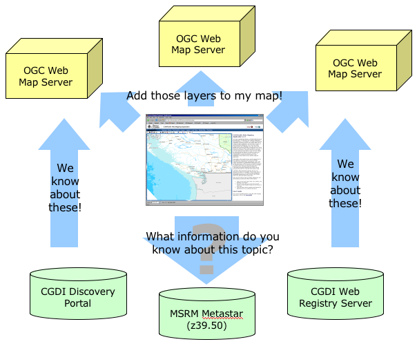
MSRM settled on an architecture based on OpenGIS web services and selected Refractions Research to gather requirements and use cases, design the system, and provide implementation and delivery.
Refractions worked with COINPacific stakeholders to gather use cases and developed a design which made use of a mix best-of-breed components and new functionality:
- UMN Mapserver as an OpenGIS-compliant web map server
- OpenIMF from Moximedia as an OpenGIS web map client
- Java-based metadata client code to extract information from provincial and federal metadata servers
By connecting the web-mapping application to the metadata services already offered by the provincial and federal governments, Refractions made the application “extensible-by-design” – whenever new information is added to the metadata servers, it becomes available to the COINPacific portal automatically.
Refractions implemented the portal, publishing new data provincial data layers using Mapserver; customizing the interface in OpenIMF to allow client-side styling, reprojection and layer manipulation; and adding a new metadata search capability to the IMF infrastructure.
The final COINPacific implementation was delivered to MSRM under-budget and on time.